Aerophotogrammetry - Taking a bird's eye view of things
From a bird's eye view, you see many things much more clearly. We use this knowledge specifically for our customers. To that end, GEO-METRIK offers a wide range of different services: image flight planning, aerotriangulation, control point determination, photogrammetric evaluation with field comparison and data preparation for the most diverse of target systems.
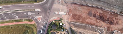
This is made possible not least by our drones, which can take off at the operating site at short notice to take low altitude aerial photographs for subsequent evaluation. A crucial advantage of this technology is that it can also be used for objects for which this technique was hitherto not an economic proposition.
In addition, photogrammetric processes and evaluation options for terrestrial and digital aerial photogrammetry have been part of our service profile for years. Drawing on this wealth of experience enables us to take on the complete project management for photogrammetry services.
References
- Digital map of federal waterways 1:2000, Rhine, km 519.7 - 549.8, survey flight, ground control point work, photogrammetric evaluation, field comparison, CAD processing
- BAB 66 Schierstein motorway junction - Erbenheim junction and BAB 671 Amöneburger Kreisel, survey flight, ground control point work, photogrammetric evaluation, digital terrain model, field comparison, CAD processing, delivery in the VESTRA system and production of orthophotos
- Regional office for the preservation of historic monuments and archaeology, Saxony-Anhalt , aerial photographic overviews of a wide range of archaeological excavations - Downloads: Case Study
- Aland- and Wrechow-Polder, monitoring, documentation of flood plains
- New development area – Zwickau penal institution – approx. 40 ha – drone photo flights followed by a quantity survey