Terrestrial photogrammetry - Getting down to basics
Introduced about 140 years ago for the pictorial documentation of architectural monuments and art treasures, this method is still in use to this day. We use terrestrial photogrammetry in the field of monument preservation and architecture for documentation, the preservation of evidence, visualisation and 3D modelling.
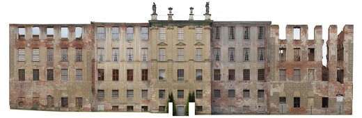
GEO-METRIK’s surveyors and technicians use this method to capture the up-to-data of buildings and structures fully pictorially. They can then evaluate the image material in detail, using in most cases the quick and inexpensive method of single-image rectification for facade views and CAD drawings for simple, flat and unstructured objects. We use stereoscopic evaluation to capture buildings that have, by way of contrast, a strong spatial structure.
We use photographic measuring cameras in medium and large format as well as state-of-the art digital camera systems for phototerrestrial photogrammetry. We use drones to capture additional features of high-lying or inaccessible sections, such as roof surfaces, enabling us to provide an accurate overview of everything for our customers every time.
References
- District court Halle (Saale), photogrammetric evaluation of the facade, single image rectification
- Dresden, historic gasometer - Asisi-Panometer, photogrammetric evaluation of the facade
- Halle (Saale), Leopoldina, photogrammetric evaluation of facade, single image rectification
- Dessau, Albrechtstraße 11/12, Petruskirche, photogrammetric evaluation of the facade, single image rectification
- Bamberg, new underground car park at Erba-Platz, photogrammetric deformation measurement